Kīlauea Eruption History Shows How Hawaii Creates New Land
Anúncios
Kīlauea’s eruption history is more than a record of dramatic lava flows and volcanic hazards. It is also a living example of how Hawaii continues to build itself, one eruption at a time. On the Big Island, molten rock doesn’t just destroy and reshape the landscape—it creates new land, layer by layer, adding fresh coastline to an island that is still growing.
For anyone interested in geology, Hawaiian history, or the power of natural forces, Kīlauea offers a rare opportunity to watch Earth’s processes in action. Its eruptions help explain why the Hawaiian Islands exist, how they change, and why the island of Hawaii is still expanding today.
Anúncios
Kīlauea and the Story of Hawaii’s Growth
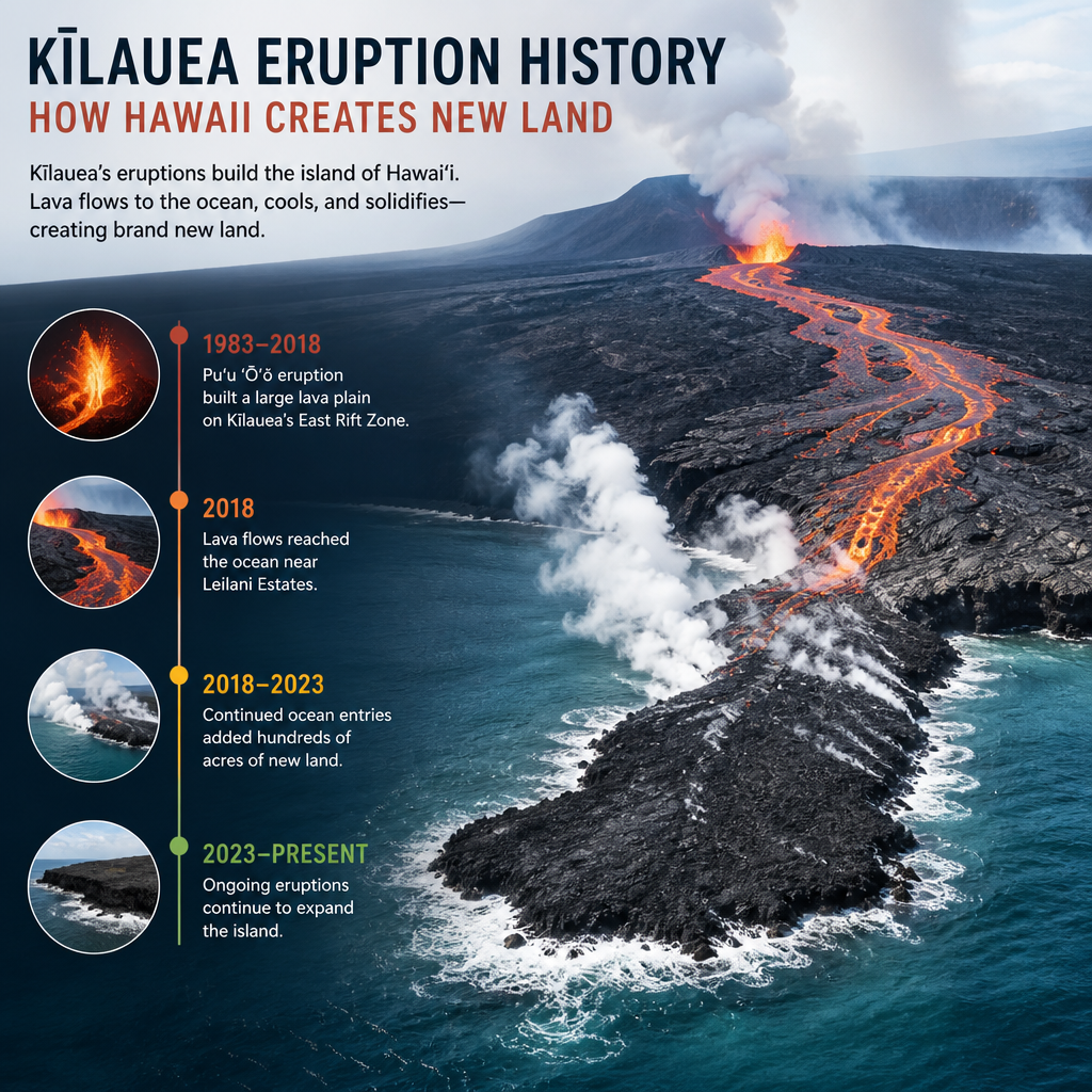
Kīlauea is one of the most active volcanoes on Earth and a central force in the ongoing formation of Hawaii’s landmass. It sits on the island of Hawaii, the youngest and largest island in the Hawaiian chain. The island formed over a hot spot deep beneath the Pacific Ocean, where rising magma repeatedly pierced the oceanic crust.
As the Pacific Plate slowly moved northwest, the hot spot stayed in place. Over millions of years, this process created a chain of volcanic islands. Kīlauea is one of the most important volcanoes in this chain because it continues to pour lava onto the surface, extending the island farther into the sea.
Anúncios
Unlike many volcanoes that erupt once and go quiet, Kīlauea has remained active for much of modern recorded history. That consistency makes it a powerful case study in island-building, volcanic geology, and hazard management.
Why Kīlauea matters to Hawaii’s land formation
Kīlauea’s lava flows do not just cover older terrain. In some cases, they reach the ocean, cool rapidly, and form new rock where there was once only water. This process can:
- add acreage to the island
- create new black sand beaches
- reshape shorelines
- form lava deltas and new coastal features
In practical terms, Kīlauea shows that Hawaii is not a static place. It is a dynamic landscape still being built by volcanic activity.
A Brief Look at Kīlauea’s Eruption History
Kīlauea’s eruption history stretches back long before written records, as Hawaiian oral traditions preserve memory of volcanic events and their effects on the land. Scientific monitoring and historical documentation later gave researchers a clearer timeline of the volcano’s behavior.
Over time, Kīlauea has shown both explosive moments and long-lasting effusive eruptions, the kind that allow lava to flow steadily rather than erupt violently. These slower lava emissions are especially important for land creation because they can move across great distances and reach the ocean.
Some of Kīlauea’s most well-known recent eruptive periods have drawn global attention, especially when lava entered residential areas or crossed roadways. Yet from a geological perspective, those same eruptions also reveal how new land is made.
The role of long-lived lava flows
Not every eruption builds land in the same way. At Kīlauea, low-viscosity basaltic lava often travels far from the vent. When it reaches cooler terrain or the ocean, it hardens into new rock. Over time, repeated lava flows stack on one another, thickening and enlarging the island’s surface.
This slow but powerful process means that Kīlauea’s eruption history is written directly into the geography of the Big Island.
How Lava Creates New Land in Hawaii
The process of new land formation from volcanic eruptions is straightforward in concept, but fascinating in practice. Kīlauea’s lava is molten rock from beneath Earth’s crust. Once it erupts, it flows across the surface until it cools and solidifies.
From lava to land
Here’s how that transformation happens:
- Magma rises through the volcano
- Beneath Kīlauea, magma moves upward through cracks and chambers.
- Lava reaches the surface
- When magma erupts, it becomes lava and begins flowing downhill.
- Lava cools and hardens
- As it loses heat, it turns into solid basalt rock.
- Layer after layer accumulates
- Repeated flows build thickness and expand the island.
- Ocean-entry lava can create new coastal land
- When lava reaches the sea, it cools quickly and may form a lava delta or fresh shoreline.
This is one reason Hawaii is often described as a “living laboratory” for geology.
New land versus temporary landforms
Not all lava-created features last forever. Some lava deltas are unstable, especially where molten rock enters the ocean and forms loose, fractured material. These areas can collapse. Other lava formations become stable bedrock that remains part of the island for generations.
That distinction matters. While Kīlauea continually creates new land, some of that land is still young and evolving.
Kīlauea’s Eruption History and the Big Island’s Changing Coastline
The island of Hawaii has some of the youngest coastline on the planet because of ongoing lava activity. Kīlauea’s eruption history has repeatedly added land to areas that were once open ocean or near-shore water.
When lava enters the ocean, it can create a dramatic contrast: bright red molten rock meeting deep blue water, followed by steam clouds and rapidly hardened black volcanic stone. Over time, these flows can extend the coastline outward.
What happens when lava reaches the ocean?
Ocean-entry eruptions can produce several features:
- Lava deltas: New land built where lava flows into the sea and cools
- Steam plumes: Clouds formed by the intense heat of lava meeting seawater
- Black sand beaches: Beaches made from fragments of cooled volcanic rock
- Sea cliffs and unstable shelves: Features that may form and later collapse
These coastal changes are part of Hawaii’s natural cycle of creation and destruction. Kīlauea’s eruption history makes that cycle visible.
A landscape in motion
Because the Big Island is so volcanically active, its shape is always changing. A coastline mapped one decade may look different the next. Roads, trails, and shorelines can be altered by lava flows, erosion, and collapse. This is not just a hazard issue—it is also the mechanism by which the island grows.
The Hawaiian Hot Spot: Why the Island Keeps Growing
To understand Kīlauea’s eruption history, it helps to understand the Hawaiian hot spot. Unlike volcanic activity along tectonic plate boundaries, the Hawaiian Islands formed over a stationary source of magma beneath the Pacific Plate.
As the plate moves, different volcanoes form over the same hot spot in sequence. That is why the islands stretch across the ocean in a chain, with the youngest volcanic activity on the Big Island.
Why Hawaii is still creating new land
The island of Hawaii continues to form because:
- the hot spot remains active
- Kīlauea continues to erupt
- lava repeatedly adds new material to the surface
- the island has not yet stopped building itself
In other words, Hawaii is not simply eroding away. On the Big Island, creation is still happening in real time.
Lessons from Kīlauea’s Eruption History
Kīlauea’s eruption history teaches more than geology. It also shows how people adapt to a powerful natural environment.
1. Nature changes faster than maps
A road, shoreline, or neighborhood can become outdated after a major eruption. This is why geologists, emergency managers, and local communities rely on frequent monitoring.
2. Volcanic land is both fertile and fragile
As lava weathers over time, it can form rich soils that support plant growth. But fresh lava rock begins barren and lifeless. Nature must slowly reclaim it.
3. Living near a volcano requires planning
Residents and visitors need to understand hazard zones, evacuation routes, and the difference between short-term spectacle and long-term risk.
4. New land comes with tradeoffs
The same lava that builds the island can also destroy homes, infrastructure, and ecosystems. Kīlauea’s eruption history reminds us that creation and loss often happen together.
The Human Side of Kīlauea’s Story
Kīlauea is more than a geological feature. It is part of Hawaiian culture, history, and identity. For Native Hawaiians, volcanic landscapes carry deep meaning, connecting people to land, ancestry, and sacred tradition.
Modern visitors often come to witness the beauty and power of volcanic terrain. But responsible tourism requires respect for both the natural environment and the communities affected by eruptions.
How to observe Kīlauea responsibly
If you visit a volcanic area, it helps to:
- stay on marked trails
- follow park and safety guidance
- respect closures
- avoid approaching unstable coastlines or lava entries
- learn from local and official sources
This approach supports safety while also preserving the experience for others.
Kīlauea in the Bigger Picture of Earth Science
Kīlauea’s eruption history is valuable because it helps scientists study how Earth creates and recycles land. The volcano provides a clear example of basaltic volcanism, island growth, and the interaction between molten rock and ocean water.
Researchers use Kīlauea to better understand:
- magma movement
- eruption forecasting
- lava flow behavior
- coastal formation
- ecological recovery after eruptions
Because Kīlauea is so active, scientists can observe changes that would take centuries to study in less dynamic locations.
Why this matters beyond Hawaii
The lessons learned from Kīlauea help improve volcanic monitoring around the world. They also reinforce a broader truth: Earth is always changing. Land that seems permanent is often the product of long, slow, and powerful natural forces.
Practical Ways to Learn More About Kīlauea
If you want to explore Kīlauea’s eruption history more deeply, start with trusted sources and observe how different kinds of information fit together.
Good places to begin
- official park and monitoring updates
- geological surveys and hazard maps
- museum exhibits on Hawaiian volcanoes
- educational resources from universities and scientific agencies
- historical and cultural materials from Hawaiian organizations
Combining science with cultural context gives the most complete picture.
Frequently Asked Questions
How does Kīlauea create new land?
Kīlauea creates new land when lava flows onto the surface, cools, and hardens into solid rock. If the lava reaches the ocean, it can form new coastal material such as lava deltas or fresh shoreline rock. Over time, repeated eruptions build up layers and expand the island.
Is Hawaii still growing today?
Yes. The island of Hawaii is still growing because active volcanoes like Kīlauea continue to erupt and add material to the land surface. While erosion also shapes the island, volcanic construction is still an important part of its development.
What makes Kīlauea’s eruption history so important?
Kīlauea’s eruption history is important because it shows an ongoing process of island formation. Scientists study it to understand lava flow behavior, coastal change, volcanic hazards, and how new land forms over time. It is one of the best natural examples of active land creation on Earth.
Can new land from lava be dangerous?
Yes. New lava land can be unstable, especially near the ocean where lava deltas may collapse. Fresh lava also releases heat, gas, and sharp volcanic rock. That is why safety warnings and restricted access areas are so important around active eruptions.
Why is the Big Island different from the other Hawaiian Islands?
The Big Island is different because it is the youngest and most volcanically active island in the Hawaiian chain. It sits closest to the current hot spot, which feeds Kīlauea and other volcanoes. Older islands have moved away from the hot spot and are no longer actively growing the same way.
Official Resources
- U.S. Geological Survey: Hawaiian Volcano Observatory
- National Park Service: Hawaiʻi Volcanoes National Park
- University of Hawaiʻi at Hilo: Department of Geology
- NOAA: Pacific Tsunami Warning Center
- State of Hawaii: Emergency Management Agency
Conclusion
Kīlauea’s eruption history offers a powerful reminder that Hawaii is not just a place of scenic beauty—it is an active, evolving landscape still being built by volcanic forces. Each eruption adds another chapter to the story of the Big Island, showing how lava can reshape coastlines, form new rock, and gradually expand the island into the sea.
At the same time, Kīlauea’s eruptions reveal the balance between creation and destruction. New land forms, but ecosystems, roads, and communities may also be affected. That tension is part of what makes Hawaii such a compelling place to study and respect. For scientists, Kīlauea is a window into Earth’s inner processes. For residents and visitors, it is a reminder to stay informed, prepared, and mindful of the natural power shaping the islands.
If you want to understand how Hawaii continues to create new land, Kīlauea is one of the clearest and most dramatic examples on the planet. Keep learning from trusted sources, follow official guidance, and look closely at the landscape—the island’s story is still being written.